Revision 554f2119fbd0d6565e4f2377791ac8928d0664cd authored by Zhang Yunjun on 09 February 2023, 10:00:11 UTC, committed by GitHub on 09 February 2023, 10:00:11 UTC
hdfeos5.md
We support output geocoded displacement time-series product into [HDF-EOS5](http://hdfeos.org) format via `save_hdfeos5.py`. This is designed to easily share the InSAR time-series product to the broader community.
```bash
save_hdfeos5.py geo_timeseries_ERA5_ramp_demErr.h5 --tc geo_temporalCoherence.h5 --asc geo_avgSpatialCoh.h5 -m geo_maskTempCoh.h5 -g geo_geometryRadar.h5
save_hdfeos5.py timeseries_ERA5_ramp_demErr.h5 --tc temporalCoherence.h5 --asc avgSpatialCoh.h5 -m maskTempCoh.h5 -g inputs/geometryGeo.h5
```
### 1. File structure ###
```
/ Root level group
Attributes metadata in dict
/HDFEOS/GRIDS/timeseries timeseries group
/observation
/displacement 3D array of float32 in size of (n, l, w) in meter
/date 1D array of string in size of (n, ) in YYYYMMDD format.
/bperp 1D array of float32 in size of (n, ) in meter
/quality
/mask 2D array of bool_ in size of ( l, w).
/temporalCoherence 2D array of float32 in size of ( l, w).
/avgSpatialCoherence 2D array of float32 in size of ( l, w).
/geometry
/height 2D array of float32 in size of ( l, w) in meter.
/incidenceAngle 2D array of float32 in size of ( l, w) in degree.
/slantRangeDistance 2D array of float32 in size of ( l, w) in meter.
/azimuthAngle 2D array of float32 in size of ( l, w) in degree. (optional)
/shadowMask 2D array of bool in size of ( l, w). (optional)
/waterMask 2D array of bool in size of ( l, w). (optional)
/bperp 3D array of float32 in size of (n, l, w) in meter. (optional)
```
### 2. Metadata
Besides [the attributes used in MintPy](./api/attributes.md), we add extra metadata inheritated from [UNAVCO InSAR Product Archive](https://winsar.unavco.org/insar/) ([format specification](https://docs.google.com/document/d/1fm6RY8aL4hhRa88M9cd_Ejh6OL3YfibfjN1UQ7TWsmI/edit?usp=sharing)) as below:
#### 2.1 required & manual
The following metadata requires manual specification in the custom template file, e.g. [WellsEnvD2T399.txt](./templates/WellsEnvD2T399.txt).
+ **mission:** short name of the air-/space-borne SAR (constellation) mission, e.g. ALOS, ALOS2, CSK, ENV, ERS, JERS, NISAR, RS1, RS2, S1, TSX, UAV [auto-grabbed for tops/stripmap/alosStack only]
+ **beam_mode:** short name of the beam mode as used by the space agency, e.g. IW for Sentinel-1, SM for stripmap, SL for spotlight, etc. [auto-grabbed for tops/stripmapStack only]
+ **relative_orbit:** relative orbit (track / path) number [auto-grabbed for tops/stripmapStack only]
+ **first/last_frame:** first and last frame number (same if only one frame) [auto-grabbed for tops/alosStack only]
#### 2.2 recommended & manual
+ **beam_swath:** value used by the space agency, e.g. 1/2/3 for Sentinel-1 IW (default: 0)
+ **processing_dem:** DEM data source used during processing, e.g. SRTM, ASTER, NED (default: Unknown) ...
+ **unwrap_method:** method used for phase unwrapping, e.g. snaphu (default: Unknown)
+ **atmos_correct_method:** method/model used for atmospheric correction (default: None)
#### 2.3 auto-grabbed / hardwired by script
+ **first/last_date:** ISO 8601 format (YYYY-MM-DD) [auto-grabbed]
+ **data_footprint:** WKT formatted polygon outlining the area covered by the data [precise; for geocoded file only; auto-grabbed from Y/X_FIRST/STEP]. This is temporary and should be merged into scene_footprint.
+ **scene_footprint:** WKT formatted polygon outlining the area covered by the data [coarse; auto-grabbed from LON/LAT_REF1/2/3/4]
+ **processing_type:** data product processing level, e.g. INTERFEROGRAM, LOS_VELOCITY, LOS_TIMESERIES [hardwired as LOS_TIMESERIES]
+ **history:** creation date and time in ISO 8601 format (YYYY-MM-DD) [auto-grabbed]
+ **processing_software:** method/software used to generate interferograms/offsets (default: isce) [auto-grabbed from PROCESSOR]
+ **post_processing_software:** method/software used to generate time-series or velocity field [hardwired as MintPy].
+ **flight_direction:** flight direction of the satellite platform, A(scending) or D(escending) (default: Unknown) [auto-grabbed from ORBIT_DIRECTION]
+ **look_direction:** R(ight) or L(eft) [auto-grabbed from ANTENNA_SIDE]
+ **polarization:** transmit and received polarization of the radar wave: HH, VV, HH+VV, etc. (default: Unknown) [auto-grabbed from POLARIZATION]
+ **prf:** pulse repetition frequency (default: 0) [auto-grabbed from PRF]
+ **wavelength:** radar wavelength [auto-grabbed from WAVELENGTH]
### 3. Filename convention ###
Inherited from [UNAVCO InSAR Product Archive](https://winsar.unavco.org/insar/) ([format specification](https://docs.google.com/document/d/1fm6RY8aL4hhRa88M9cd_Ejh6OL3YfibfjN1UQ7TWsmI/edit?usp=sharing)), we use the filename convention below:
<SAT>\_<SW>\_<RELORB>\_<FRAME1>(\_<FRAME2>)\_<DATE1>\_<DATE2>(\_<SUB>).he5
E.g. S1_IW12_128_0593_0597_20141213_20170928.he5
| Items | Descriptions | Values |
| --------- | ------------ | -------|
| <SAT> | Mission name | ALOS, ALOS2, CSK, ENV, ERS, JERS, NISAR, RS1, RS2, S1, TSX, UAV |
| <SW> | Beam mode with swath number | SM2 (for ENV), IW3 (for S1) |
| <RELORB> | Relative orbit (track) number | 3 digits with zero padding |
| <FRAME1> | Start frame number | 4 digits with zero padding |
| <FRAME2> | End frame number | 4 digits with zero padding; shown only if it's different from \<FRAME1> |
| <DATE1> | Start date | YYYYMMDD |
| <DATE2> | End date | YYYYMMDD; "XXXXXXXX" if update mode is ON. |
| <SUB> | Subset range | N{:05d}_S{:05d}_W{:05d}_E{:05d} in degrees; number with precision of 3 digits after decimal * 1000; e.g. S00500_N01300_W001200_E005800; shown only if data is cropped. |
### 4. Web Viewer ###
HDF-EOS5 file format is used as the input of the University of Miami's web viewer for InSAR time-series products. Below is a screenshot of the web viewer for the dataset on Kuju volcano from ALOS-1 acending track 422.
<p align="center"><b>http://insarmaps.miami.edu</b><br></p>
[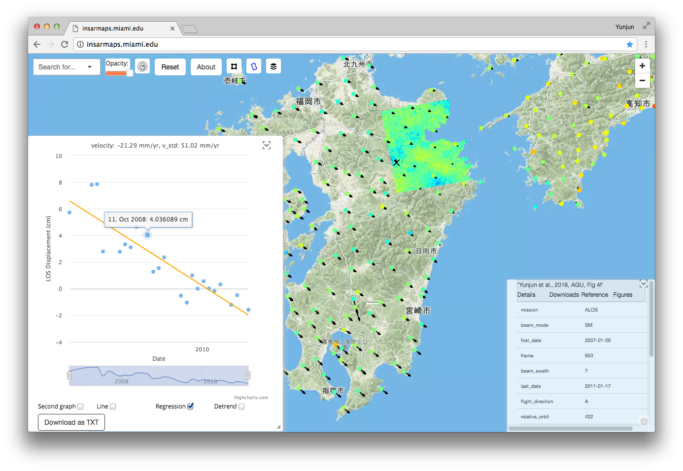](http://insarmaps.miami.edu/)

Computing file changes ...